A Natural History of
Queensland Snow From 1878
by
Nicholas Oughton
Updated: 1st November 2022
Strictly speaking, it should not snow in sub-tropical Queensland, but
it does, and perhaps more often than you would think! When the chill thrill
calls, many Queenslanders head for the snowline.
These pages provide a history of Queensland snowfall; descriptions of
the most dramatic events; how to predict a snow event and; where snow is most
likely to be found in South-East Queensland. It’s a do-it-yourself guide to
predicting, finding and enjoying the wonder of Queensland snow.
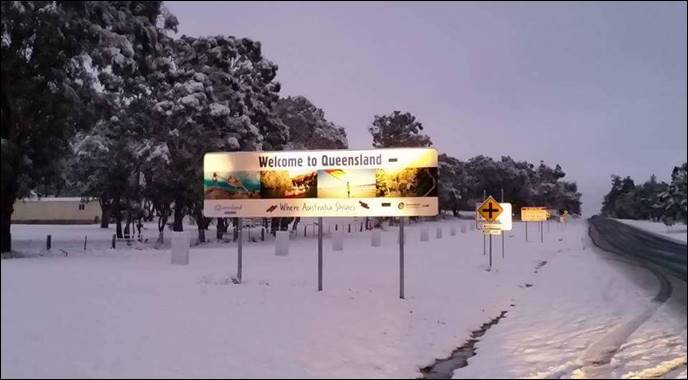
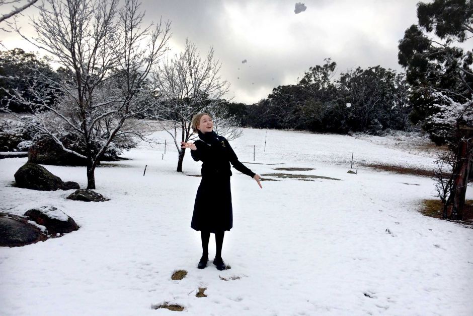
Welcome to snowy Queensland. Wallangarra in the early morning of 17 July, 2015.
The Romance of Snow
He
who has seen the eternal snows,
Noonday
white and evening rose,
Though
he descends down into the plain,
Never
is the same again,
And
in the mind and dirt and sweat,
Cannot
lose, cannot forget,
The
radiance of the eternal snows,
Noonday
white and evening rose.
(Anonymous)
Check out these pages
also…
Additional stories can be found here:
A personal account of the 1984 snow event
A snow chaser’s guide to finding snow in
Queensland
Snowfall records for Queensland from 1878
Some unusual Queensland snow events
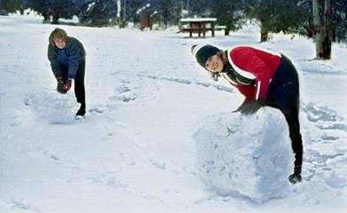
Building a Snowman, Girraween National Park,
Queensland, 4th July 1984.
Photo courtesy of Ulrike and Siegfried Manietta
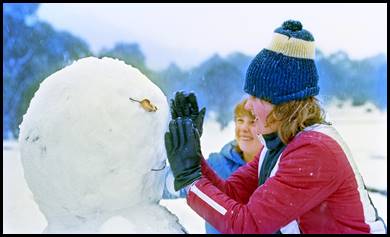
‘Job
done’ Girraween National Park, Queensland, 4th July 1984. Photo
courtesy of Ulrike
and Siegfried Manietta
For many children, the
excitement of freshly fallen snow and the magical transformation it makes of a
familiar world is seldom forgotten. For
those who have never seen snow, stories of white Christmases; Artic adventure;
the conquest of high mountains; winter holidays in exotic countries; and fairy
tales set in unfamiliar snow bound countries infuse a powerful mythology – one that lasts into adult life.
For those who don’t live
among the eternal snows, but where snow is more rarely experienced such as
South-East Queensland, winter snowfall provides a diversion from the humdrum
regularity of everyday life – a period of imaginative escape – a remnant of childhood dreams and
fantasies.
Unusual falls of snow can
transform people, making them more gregarious, good humored and generous of
spirit. When it snows in Queensland, many folk pack up their cars with warm
cloths, children and excitement, and head for the Queensland snow line – to
build a snowman, throw a snowball, enjoy a glass of wine by a fireside, a
Christmas in July.
Above the Queensland snow line. Snowman and
friends at Wallangarra 17th July, 2015
Snow in South-East Queensland
Historically
speaking, snowfall in Queensland is not rare occurring on average a little more
than once per year over the past 144 years. However, several years may pass
without snow falling somewhere in Queensland.
Snow
has fallen as far North as the Clark Ranges near Mackay, as far West as Texas
and has even been observed falling in Brisbane.
According
to the ‘Argus’ of Tuesday 8th August 1982.
The reported
fall of snow in Brisbane has been confirmed by many persons who witnessed it.
The snow was most noticeable in Woolloongabba, but in Stanley Street, South Brisbane,
it was sufficiently heavy to allow of people wiping it from their clothing...It
is said that snow fell in this city 35 years ago. At Toowoomba, the local
paper says, on the same date, "towards 12 o'clock, light
flaky snow began to flit about, and these were followed by unmistakable
drifting showers of real snow. Spring-hill road was quite white, as were
also the footpaths in some parts of the town, and we learn that at Clifton-plains
about 2in. of snow covered the ground.
Two Recent Big Snow Events in in South
East Queensland
The Big Snow, 13th to 17th
July 2015
This surprising event commenced on Sunday 13th of July with snow
flurries and sleet at Eukey some 12 kilometres from Stanthorpe. Local cafe owner Amanda
Blair said business had been booming in the border town since Saturday.
"It has been so busy. From 7:30am in the morning there was a stream of
traffic heading south and it was like that all weekend," said Ms. Blair.
"As soon as people hear about snow they head to the border". Snow again
fell at Eukey on Monday the 14th with settling falls just over the
Border at Mt Mackenzie. These events, however, were just teasers for what was
to follow.
Observing this exciting event in the late evening of July 16th,
Ken Kato wrote: “At approximately 11:40pm some tufts of cloud started to appear
– then within
the space of only a few mins it went from absolutely clear skies to totally
overcast. The first flakes fell at 11:45pm. By midnight, it started to really
come down. By 1am, it was close to blizzard/snowstorm conditions at times, with
wet snow changing to dry powder snow for quite a while. Dry snowflakes were
blowing horizontally with gusts of wind roaring through the trees and making the
power lines hum. Visibility was down to around 100m and snowdrifts began
forming,
I almost got bogged in deep snow near Eukey in an area with no mobile phone
reception so I thought I might have to flag down a passing motorist. The only
thing that saved me was collecting a mass of sticks and stones to put under my
tyres to get just enough grip to get out. The weight of the snow was also
bending many of the branches on smaller trees right over onto the road itself.
I got bad frostbite despite wearing boots, socks and gloves due to prolonged
exposure to snow and wind-chill; and having to take gloves off to take pics and
video.
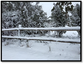
Snow
on the fence near Eukey morning of the 17th July 2015. Photo courtesy
of Ken Kato
Ken’s snow chasing on the night of 16/17th July reminds us of
precautions we should all take when exposing ourselves to extreme weather
events. I also snow-chased on the Granite Belt with my family on Friday 17th; imbibing a
lovely locally produced red over lunch at a local Winery.
The author, Nicholas Oughton, 17th
July 2015 at 2.06pm. Eukey Road west
of Hidden Creek Winery. Photo Sue Pickford
The Great Fall of July 1984
An extraordinary lemming
like rush to see Queensland’s very own snowfields began when hundreds of
sightseers headed for the Granite Belt. The local telephone system became
overloaded and broke down as people endeavored to tell their friends of the
great event. To read my personal account
of this great event, go here.
Snow began falling on The
Granite Belt on Tuesday 3rd of July with falls continuing intermittently
till Thursday the 5th. Heavy falls were recorded at Mount Tully and
Eukey (South-East of Stanthorpe) where the snow cover was reported to be 60cm
deep in surrounding areas with 15cm in the town. In Stanthorpe, the snow was
‘welcomed with sheer delight by most residents’ (Border Post July 5 1984). The
snowmen and snowball fights that erupted on every corner of the town attested
to the general euphoria. To the east of the Stanthorpe, graziers began moving
ewes, and lambs into shelter as the snow persisted.
‘Just like a Christmas
scene’ is how stranded Warwick bowler Mrs. Pat Collins described the view from
her Tenterfield motel room as she and five friends played cards watching the
snow fall (Daily News July 4 1984). The bowlers, who were visiting Tenterfield
became stranded when snow and ice made the road back into Queensland dangerous.
In Brisbane, ‘It also tried
hard to snow’ reported a spokesman for the weather Bureau. Guests on the 21st
floor of Lennon’s Hotel in the city told how they had seen snow blowing past
their windows. The snow, however, turned to sleet before hitting the Brisbane
streets. The closest settling snow to Brisbane fell on Mount Tambourine and Mount
Glorious, both a one-hour drive from the City.
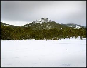
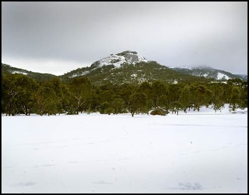
‘The Pyramids’, Girraween National Park,
viewed across open fields during the
snow even of July 1984. Photo courtesy of Ulrike and Siegfried
Manietta.
There are ways to forecast
snowfall in Queensland using information from weather maps and chatter on
social Webb sites. For a snow chasers guide to predicting and finding snow in
Southeast Queensland go here.
The
Snow Fall Record for Queensland from 1878
The snowfall record for
Queensland from 1878 to date has been compiled from a number of sources
including the Bureau of Meteorology (BOM) Brisbane, newspapers, observer
reports, dated photos and my own records. This record with comments can be
found here.
Are There Cycles in Snow Years?
An analysis of South-East Queensland
snowfall history from 1878 shows a very loose cycle of approximately 4-5 years
between good and poor snowy winters. This cycle, however, cannot be relied on
in a predictive sense. Sadly, for snow lovers, the snowfall trend shows a
steady decline. However, snow can fall somewhere in South-East Queensland at any
time between the months of May and November averaging a fall every 1.16 years.
A
second loose cycle shows a rotation of approximately 30-years between peak snow
periods in South East Queensland. The most recent of these ‘fuzzy’ cycles
should have peaked in the early 1990s, but did not arrive – climate change perhaps? The next peak should
occur in the early 2020s – if at all. In addition, the gap years with no snow
are becoming more frequent.
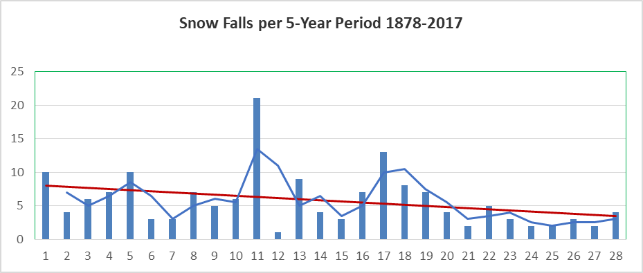
Figure 1.
Notes on Figure One
Figure
one is a graph snowing the snow days occurring in South East Queensland,
(predominantly the Southern Downs and Granite Belt districts) during the past
144 years. There have been 164 snow days during this period, which represents
just over one snow day per year. Figure one also shows the trend line (orange)
which shows a snow-day decline of around 50 per cent for the period.
Clearly
the 50-year period from 1926-1975 was prominent for snow in South East
Queensland realizing 60 per cent of total falls occurring during the past 144
years. Eighty snow events of 2-4 days occurred over last 144 years in South
East Queensland, thus there is a 55 per cent chance of a snow ‘event’ (e.g.
falls on more than one day) happening somewhere in SE Queensland.
There
have been two major 4-year snowy periods in Southeast Queensland. These were 1926-1929,
period 13 and 1958-1961 (period 11), see figure one. Such snowy periods could
occur again, however, climate change in SE Queensland works against this
probability.
Prior
to the 2015 event, Peter Burr (Armadale Weather) wrote that: “With winters
becoming milder it seems unlikely that any further major evets such as 1984
will occur again. However, with the ever-increasing erratic nature of weather
systems, nothing can be ruled out. With the right conditions occurring during
the winter months, other heavy snowfall events are still possible”.
Peter’s
prediction came true in July 2015, with widespread heavy snow spread from the
Central Tablelands of NSW to Queensland’s Granite Belt and border ranges.
University
of Melbourne climate scientist Professor David Karoly adds that: “Natural
variability in the weather is still very important, so while you have climate
change and global warming, that doesn’t mean that occasions of cold extremes suddenly
disappear. It just means there will be a reduced frequency of these cold events
occuring”.
The Best Time to see Snow and Sleet in S.E.
Queensland
Figure
two shows that the best dates to observe snow or sleet falling in SE Queensland
is the 20-day period (periods 9 and 10 in figure 2), being the 11th -
30th July. According to past records, forty per cent of snow/sleet
in SE Queensland occurs in July. The red line shows the 2-period moving
average.

Figure 2.
See the page ‘A snow
chasers guide to finding snow in snow in Queensland’ for Snow predicting tools.
Fun in the Snow,
in Stanthorpe, 17th July, 2015. Photo courtesy of the ABC
Glancing upwards,
as the clouds glide across the moon,
Silver stars are
out mingling with the drifting snowflakes,
A sight to enjoy
here and now, for morning will be here soon,
A beautiful
Christmas memory, deep in my heart to take.
Only one car
comes up the street, as I walk along our lane,
Just a friendly
snowman is there to greet me with a hello,
I stop, adjust
his top hat, and reposition his pipe and cane,
This cold-hearted
man has made a child smile, I know.
My ears lead me
to the street corner where carollers sing,
As those old
familiar notes drift towards me on the air,
More sounds seem
to awaken as the bells distantly ring,
I felt nothing
but a warming glow as I was standing there.
Extract form ‘Christmas Snow’ by Kelly
Deschler
If
any reader has a snow story of their own, please contact me by email. I would love
to use your story in these pages if you are happy for me to do so. Also, your
observation and report of snow falling in SE Queensland will make a valuable
contribution to the record of snow in our State.
Nicholas
Oughton is a former Associate Professor from Griffith University in Brisbane,
Australia. For further information contact Nicholas Oughton at: najoughton@gmail.com
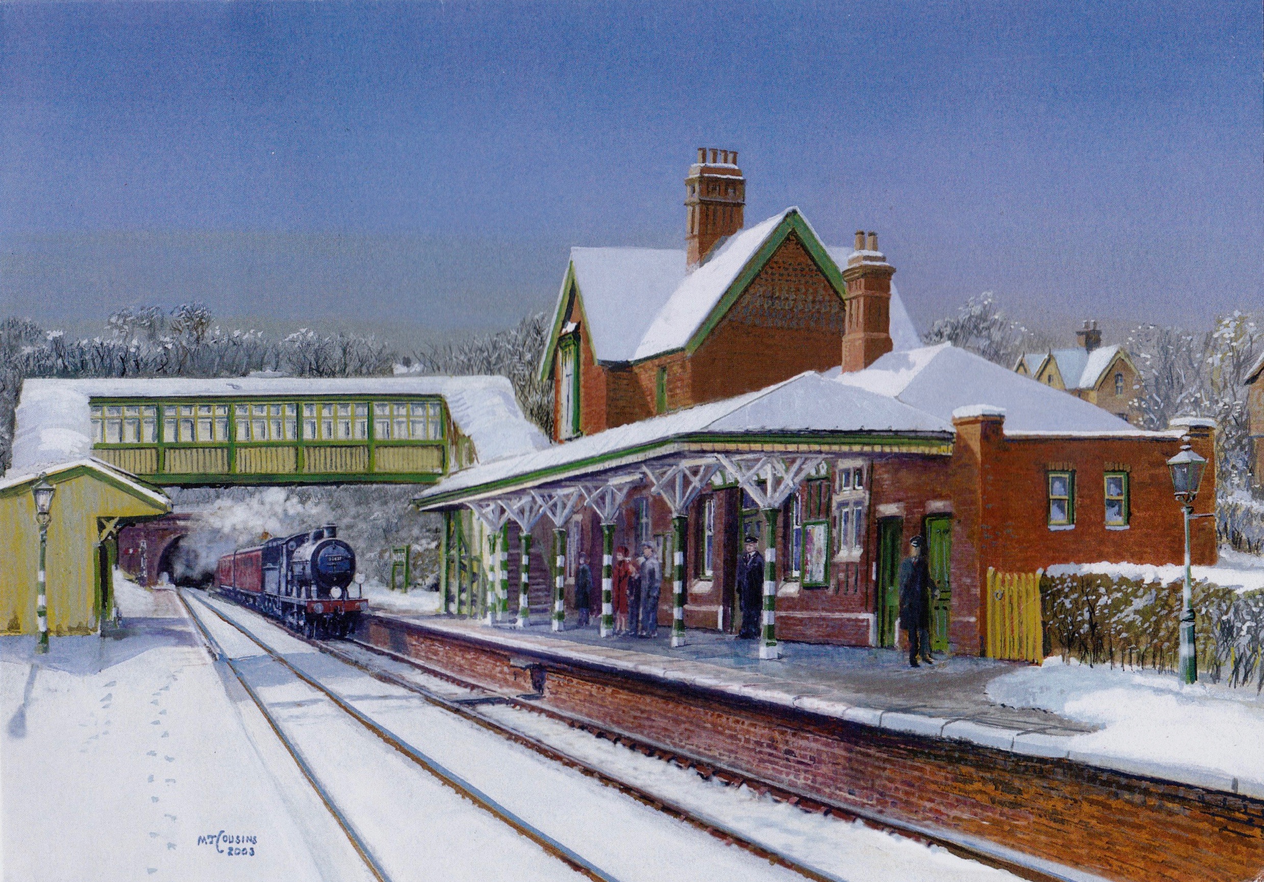
The romance of Snow. My Cousin Matthew is a fine
painter of railway themes. This painting shows
a passenger service arriving at snowy West Hoathly (UK) in the early 1950’s.
The picture, courtesy
of Matthew Cousins