Snow Chaser’s
Guide to the
Granite Belt and Southern Downs
Nothing
is quite so quiet and clean
As
snow that falls in the night,
And
isn’t it jolly to jump from bed
And
find the whole world white.
And
while we are having breakfast
Papa
says ‘Isn’t it light?
And
all because of the thousands of Geese
The
Old Woman plucked last night’.
(From ‘Snow in Town’ by
Richard Mark)
The Magic Of Snow
An enduring child
hood memory for those that live in colder climates is to wake on a winter’s
morning to a world made white with snow. The first sensation is the enveloping
silence (snow absorbs sound like an acoustic title), the second, is the lasting
impression of countryside transformed, morphed into a Christmas card – the
sorcery of winter – the magic of snow.

An old-time
explanation suggests that snow is caused by an old woman plucking a Goose, or
shaking her feather bed. The Goose down magically transforms into snowflakes as
it falls gently to Earth. No doubt the
residents of the Bunya Mountains, waking up on the morning of the 13th
July 1960 to 15cms of snow had a more scientific explanation. The same may be
said of Granite belt residents who had a similar experience on the Monday
morning of 17th August 1953.
Snow generally
results from the conversion of water vapor into solid crystals of ice at
temperatures below freezing. If these snow crystals descend through warmer
layers of air, their edges become wet, cling together to form snowflakes.
For those of us
who live in the sub-tropics, snow is an elusive yet exciting phenomenon, and
when it does visit higher ground within a few-hours-drive from where we live – or even closer – many of us indulge in an activity known as
‘Snow Chasing’.
Predicting
a Snow Event for a Snow Chase.
For Queenslanders, the nearest potential snow fields are
found in the Granite Belt and Southern Downs.
Rising to over 1000 meters, this country is occasionally transformed by
a blanket of snow. Forecasting such events in order to plan a snow chase is
tricky, but possible given that the right information is used.
Snowfall in this region relies on a coalition of cold
air, moisture and precipitation arriving together, usually at night or in the
early morning over ground over 800 meters. Daytime snow is certainly possible,
and has occurred on many occasions. However, warmer daytime temperatures
generally melt snow cover quickly.
In most cases
precipitation will fall as snow when the air temperature is at or below 2 degrees
centigrade. When icy precipitation falls through warmer air it absorbs a great
deal of heat (Latent Heat) as it changes state from ice to water, thus cooling
the surrounding air. Paradoxically,
therefore, snow can fall when the general air temperature is some degrees above
freezing.
Some other factors
to consider when planning a snow chase are:
·
Ground
Temperature: has there been a recent period of frosty weather to cool surfaces. Snow settles best on cool and dry ground;
·
Wind
direction:
In most cases a Southwesterly
or Westerly wind brings snow to Queensland.
A further
consideration is to ensure that you, your family and friends stay safe during
the excitement of a snow chase.
Reading Weather Maps
Timing is
important when attempting to catch snow falling in South East Queensland’s high
country. Arrive too early and you will beat the snow, too late and melting snow
with only patches remaining in gutters and shaded areas will welcome you. To
get your timing right, a good place to start is by observing weather maps
produced by the Bureau of Meteorology (BOM). The Medium Sea Level (MSL)
pressure chart can show a developing snow scenario some days before the actual event occurs.
Snow Falls on the Granite
Belt, July 8th, 1974
Heavy snow fell on
the Granite Belt in the early morning of the 8th July 1974. The
following mean sea-level pressure map (see chart 1) shows the set up in the
early morning of that day, which delivered this exciting event. Note the strong
Southerly fetch of cold wind (from the Antarctic) indicated by the north south
line of the isobars. Isobars are lines that join areas of equal pressure. A deep Low sits over the Tasman Sea, while a
high-pressure system lingers over central Australia – a classic scenario for snow from Tasmania to Southern
Queensland.
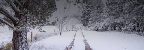
Early morning is a good time to catch snow
on the Granite Belt or Southern Downs
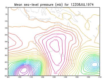
Chart 1.
Three days prior
to this event, the chart showed a set-up signaling the potential for snow to
fall within a few days over non-Alpine areas of Australia’s East Coast,
including the Granite Belt (see chart 2).
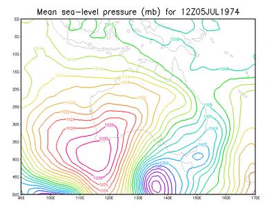
Chart 2.
Note the Low, with
a central pressure of 990 millibars emerging from the
Bight with the prospect of migrating in a North Easterly direction into the
Tasman Sea. The wind rotates clock-wise around Low-pressure systems, in this
case from deep in the cool Southern Ocean.
Days of The Big Freeze: Icy
Antarctic Blast Sweeps in to Queensland, 3-5th July 1984
The snow event of
3-5th July 1984 was quite extraordinary. The following MSL pressure
chart for the 4th July (see chart 3) shows a similar scenario to the
1974 event discussed above. On this occasion, however, the Low-pressure system
is cut-off by a ridge of high-pressure to its South.
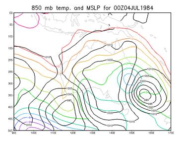
Chart 3.
The Blue circles over South-east Queensland
denote the Cold pool of air at -3C that hovered over the area for some days. An
850mb temp indicates (very approximately), the air temperature at 1500meters
above sea level. This temperature will
be found at lower levels at night.
A Cold Outbreak with Heavy
Snow in Queensland, 16-17 July 2015
From
the 11th July, a sequence of strong cold fronts passed across
South-eastern Australia bringing widespread snow to non-Alpine region of
South-eastern Australia. These falls extending along the Great Dividing Range
from west of Sydney to the Granite Belt where snow showers and sleet were
experienced. This event culminated in Queensland, with the stunning snowfalls
of the 16th-17th July.
The MSLP Chart for
10.00 EST on the 15th July, (see chart 4) issued a day and a half
before flakes began falling late on the 16th shows a classic set-up for
South-east Queensland snow. Note the High pressure ridging to the South of the
Low-pressure system, holding it back from a Southerly retreat.
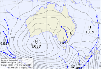
Chart 4. Courtesy of the BOM
Some 13-hours
before snow commenced falling (see chart 5), the set-up is confirmed and a cold
front passes through South-east Queensland dragging cold air behind it. This chart shows the classic pincushion
effect of the high-pressure system centered over the Bight and the low-pressure
area located in the Tasman Sea.
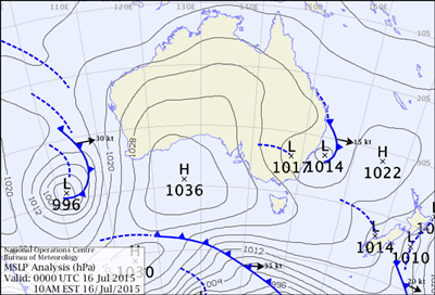
Chart 5. Courtesy of the BOM
Chart 6, shows a
number of factors, which can help predict the possibility of snowfall in
Queensland. This chart indicates the prevailing
weather situation at 10 pm on the night of 16th July, just prior to
the snowfall. The chart shows:
·
A cold
and strong, south-westerly airflow sweeping across South-east Queensland
emanating from well south of Australia;
·
A pool
of cold air (the black circle) at freezing point (850 hPa
Temperature) over South-east Queensland and;
·
Moisture,
indicated by the green area on the chart associated with the cold pool
Each of these
factors indicates a possibility for sleet or snow to fall over the Granite Belt
and Southern Downs.
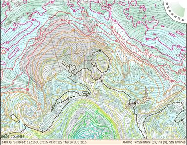
Chart 6. Courtesy of Australian Weather News
Australian Weather News is one of the most comprehensive weather sites
focusing on Australian weather available. You can visit this site at:
http://www.australianweathernews.com/
The Cold pool
Pools of cold air
commonly drift over South East Queensland in winter. Chart 7 below clearly shows a cold air pool
(outlined in blue) sitting over the western edge of the Granite Belt on
Thursday night the 11th October 2012. This event brought
non-settling morning snow showers to the Granite Belt in an unusual late season
event. Note the green-orange areas on the chart that indicate moisture
associated with the cold air.
The High (once
again displaying the pin cushion effect) is centered over the Australian Bight,
while the Low sits on the coast of NSW. This is a classic set-up for snowfall
on the Northern Tablelands. The town of Guyra, situated five and a half hours drive south from
Brisbane received heavy snow in this event.
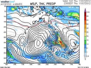
Chart 7.
Courtesy of Weatherzone
Weatherzone is another excellent weather site and can
be found at: http://www.weatherzone.com.au/
Cold Fronts
When significant cold
fronts sweep across Australia’s Southeast, they can
produce snowfalls that spread from the Southern Tablelands to Queensland.
However, accompanying moisture can be depleted by the time these fronts reach
their northern extremity. A high-pressure system normally follows the passage
of a cold front and this itself will lift the freezing level.
These setups are
easier to forecast, but generally produce light snowfalls if at all. Orographic
effect (the lifting and cooling of moisture laden air while passing over
mountain ranges) plays a role in where the snow will fall. Thus, as the
predominant snow bearing winds that pass over the Granite Belt and Southern
Downs come from the South West, it is the South-Western slopes that should
receive the most snow.
Some experienced
snow chasers believe that cold fronts are becoming less frequent over South
East Australia, and in addition, those that do often fail to reach South East
Queensland.
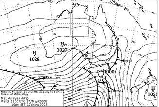
Chart 8.
Courtesy of the BOM
A strong cold
front and associated pre-frontal trough did scrape by the Queensland border on
the 17th May 2008. Snowfalls commenced between Armidale and Glencoe about
9.30pm on the 17th May with heavy falls occurring between Black Mountain and
Ben Lomond from 10pm to midnight. Six to seven centimeters of dry powder snow
covered all the higher terrain within that two-hour period.
Applethorpe (near Stanthorpe)
received rain showers with a temp of 2.9 at 1.00am on Sunday 18th.
With a moist adiabatic laps rate, this implies a temp
of 0.6C for the highest parts of the Queensland border – cold enough for sleet and snow, but neither was
reported. Mount McKenzie 35 Ks south of
the border did have snowfalls.
Snowfall Prediction Maps
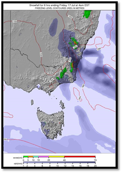
Chart 9. Courtesy of Snow
Forecast. Com
Snow predictions
such as that shown in chart 9 can be useful predictors of coming snow events.
This map gave a strong indication of snowfall (the area in green) in Northern
NSW and Southeast Queensland from 10.00pm on the 16th July
2015. Snow forecast maps can be found
at:
http://www.snow-forecast.com/maps/static/aus/full
The Snow Chasing Season
Chart 10 shows
historical snow and sleet days that have occurred in South East Queensland over
10-day periods from 1878. The 6-week period from 20th June to 30th
July (periods 7-10 on the chart) is when most falls can be expected. This is a
key time to check weather charts for the possibility of an unfolding snow
event, but be on guard as surprises can happen with early or late season falls sneaking in under the radar.
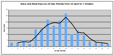
Chart 10.
Picking a
Location for a Queensland Snow Chase.
Location is
another factor to consider. Whereas snow
cover may occur over a wide area in extreme events, for example in 1949, 1959,
1960, 1974, 1984 and 2015, in more marginal events, picking the spot where snow
is most likely to fall is critical. Historical records, height of terrain,
prevailing wind, snow shadow and orographic factors can assist this
choice. My own preference when snow
chasing on the Granite Belt is to the South of the Eukey/Glen
Aplin road where the ground rises to 1113 meters.
However, study
local topographical maps look at the weather charts and make your own selection, you may find the perfect place to chase snow.
Also take and share pictures with you friends, they will most likely also be
excited by the prospects of snow chasing in Queensland. Drive safely and Enjoy!
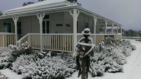
The Magic of Snow, Queensland Style. A Granite Belt Garden magically transformed by snow
17th
July, 2015. Twisted Gum Winery, home of some great Queensland wines
Let it Snow!