Recording the Weather
in Armidale NSW
History
Early settlers on the Northern Tablelands in the early 1800s noticed the
similarity between the climate here and in some parts of England, warm summers
and cold winters with severe frosts and occasional snowfalls, hence the region
gaining the name "New England." Some of these pioneers made their own
temperature and rainfall measurements with claims that temperatures as high as
39 degrees C (102 deg F) had been recorded, and as low as -12 degrees C (10 deg
F).
POST OFFICE - 1857 TO 1965
In the second half of the 19th century the government commenced setting up a
network of weather stations in the main cities and towns across the country.
Post offices were mostly chosen as the sites for these weather stations with
the postmaster being in charge of recordings. In Armidale the post office,
which was located a short distance to the west of the present building, became
the official weather station from December 1857. Daily readings taken included
rainfall, temperatures, wind, pressure and cloud cover. In 1880 a new post
office building was built at the corner of Beardy and Faulkner Streets where
weather recordings continued until 1965.
RADIO STATION 2AD - 1965 TO 1997
Because the area at the back of the post office was gradually being "built
out" the Bureau of Meteorology moved the weather station a distance of
about 100 metres to the back yard of Radio Station 2AD in Rusden Street between
Marsh and Faulkner Streets in July 1965. This was a more open area, and because
the radio station was staffed almost around the clock seven days a week, it was
convenient for staff to keep up the seven observations per day which the Bureau
required.
Recordings continued there until June 1997 when a further move was necessary.
UNE EAST ARMIDALE SITE - FROM 1997
Over the years from 1965 the area around the back yard of the radio station
slowly suffered the same problem as the rear of the post office. New buildings
and bitumen car parks were built. In June 1997 when the 2AD backyard was about
to be replaced by a carport and cement carpark, the weather station was
relocated to the site of the University of New England (UNE) weather station in
Mann Street, East Armidale which had been in operation at this location since
October 1980. This was a move of about one kilometre to an area of slightly
lower temperatures and greater incidence of frost, so the Bureau of Meteorology
decided not to amalgamate records from the former and new sites, but to
commence a new set of records at the UNE location. During the 16 years that
both stations were operating in parallel maximum temperatures averaged 1.1
degrees lower and minimums 1.7 degrees lower at the UNE site.
AIRPORT WEATHER STATION - FROM 2001
In 2001 an automatic weather station (AWS) was set up at Armidale Airport by
the Bureau of Meteorology to replace a similar AWS which had been operated in
the same location by the Dumaresq Council since 1993. This new weather station
is completely automatic providing the Bureau with continuous readouts of
temperatures, humidity, rainfall, pressure, wind, visibility and cloud height.
The airport station is 93 metres higher and five kilometres from the East
Armidale station often resulting in moderate differences in temperatures and
rainfall. Because the airport is on a plateau and the East Armidale station is
in the Armidale valley, the airport overnight temperatures are often around two
to five degrees higher than the city. During the day the airport is windier
than the more sheltered valley causing day temperatures to frequently be about
one degree lower than the city.
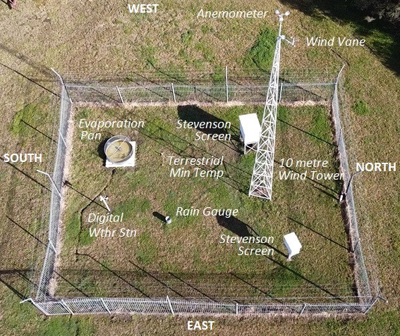
Instrumentation at East Armidale Weather
Station
The Bureau of Meteorology weather station is located in East Armidale within
the valley of Dumaresq Creek at an elevation of 987 metres above sea level.
Temperature
Temperatures are measured with mercury and alcohol thermometers which are read
by observers at designated observation times daily. These thermometers are very
accurate measuring the temperature in tenths of degrees.
They are housed within a Stevenson Screen which is a white painted timber box
with louvred sides with the base about 1.1 metres above the ground. The louvres
allow outside air to move slowly past the instruments while protecting them
from direct sunlight, wind and rain, and temperatures recorded this way are
referred to as screen or shade temperatures.
Mercury thermometers supply current dry and wet bulb temperatures.
A mercury thermometer records the maximum temperature for the 24 hours to
An alcohol thermometer records the minimum temperature for the 24 hours to
A thermograph was in use until
2019 recording the temperature continuously onto a seven day graph which
was used to determine the times at which maximum and minimum temperatures
occurred.
An alcohol minimum thermometer on the surface of the grass records the
overnight terrestrial or grass minimum temperature. The terrestrial
minimum is usually between two and five degrees lower than the screen minimum.
From 2019 temperatures were also recorded by a digital weather station.
Rainfall
Rainfall is recorded with a rain gauge set in the ground with the top 30
centimetres above the ground. It consists of a metal drum with a funnel 203
millimetres in diameter and a plastic measuring cylinder within. Rainfall is
totaled for the 24 hours ending
Evaporation
This is measured using an American Class A pan 1206 millimetres in diameter and
250 millimetres deep. At
Wind
A wind vane mounted to a ten metre tower is used to determine the wind
direction to 16 points of the compass. A cup anemometer, also mounted to the
tower, is used to calculate the wind speed and the wind run for the 24 hour
period ending at
Cloud
Details of clouds including amount of cloud covering the sky in eighths, height
of clouds, and the type of clouds are observed and recorded.
Visibility
Horizontal visibility is estimated. This is reduced by precipitation, fog, and
on some winter mornings and evenings by Armidale's woodsmoke haze trapped in
the valley.
Phenomena
Other aspects of the weather referred to as phenomena are also recorded. These
include: frosts, fogs, hail, snow, thunderstorms and strong winds.
Aerial view of weather station on 10 August
2021 showing location of instruments
Manually operated weather stations, such as the East
Armidale weather station, continue to remain a part of the Bureau of
Meteorology’s network as human observers can observe and report conditions that
automatic weather stations are unable to do, such as details of clouds,
thunderstorms, hail (size and quantity of hailstones) and snowfalls (depth of
snow on ground).
The Bureau, however, is gradually phasing out many of the manual weather
stations, particularly those which are in close proximity to automatic
stations.
East Armidale Weather Station Timeline
July 1980 - Weather station enclosure
constructed (10 x 12 metres) in a reasonably open area of land used for field
studies by the Armidale College of Advanced Education, formerly the Armidale
Teacher’s College.
The
location is bounded by Taylor, Mann, Kennedy
and Kentucky Streets. The weather station is about 80 metres west of a
gully known as Black Gully at an altitude of 987 metres above sea level. The
area is on a gentle slope with some trees nearby, and the station was set up in
the centre of a cleared paddock formerly used to graze sheep. Large Stevenson
screen installed.
11 October 1980 - Daily 9am
readings, except on weekends, of temperatures and rainfall commenced.
Thermograph used to determine maximum and minimum temperatures on Saturdays and
Sundays.
2 December 1980 - Ten metre wind
tower erected with wind vane and anemometer mounted at the top. 9am run of
wind, wind direction and wind speed readings commenced.
13 January 1981 - 9am soil
temperature readings commenced at depths of five and ten centimetres.
13 February 1981 - Terrestrial
(grass) minimum temperature readings commenced.
9 July 1982 - 9am soil temperature
readings commenced at depth of 20 centimetres.
22 November 1982 - Evaporation pan
installed. Evaporation readings commenced from 23 November.
26 February 1993 - Soil temperature
readings ceased.
1994 - The Armidale Tree Group set
up its nursery immediately to the north of the weather station with its
boundary fence about twenty metres from the station. A number of trees were
also planted in the general area, which after about ten years had grown tall
enough to probably have some minor effect on wind and evaporation readings.
18 June 1997 - The Bureau of
Meteorology commenced readings at the site. A second Stevenson screen
containing BoM instruments was installed in the enclosure with a team of
observers taking four observations daily at 9am, 12 noon, 3pm and 6pm from this
date.
1 May 2001 - Observation schedule
reduced to twice daily at 9am and 3pm.
2015 - Trees within 40 metres to the
south and east of weather station growing to heights in excess of 18 metres. A
row of tea trees along the Tree Group boundary fence within ten metres north of
the weather station growing to heights of around five metres.
1 August 2015 - Observation schedule
reduced to one daily at 9am.
17 September 2019 - Digital weather
station installed with data uploaded to weather website about twice per minute
24 hours per day. Temperatures recorded by this weather station are in close
agreement with manual thermometers (+- 1.0C), however rainfall usually
overreads by about 20 per cent, and wind direction and speed are compromised to
some extent due to the height above ground of only 1.5 metres.
January 2024 - The row of tea trees,
which had grown to a height of five to six metres, was cut back almost to
ground level which opened out the area to the north of the weather station.
23 January 2024 - The tree nursery
constructed a greenhouse four metres from the weather station fence on the
eastern side. The greenhouse is approximately 10 x 20 metres, walls three
metres, curving to a maximum roof height of 5.8 metres. The structure has a
metal frame covered by semi-clear plastic with no internal heating. After two
years it appears to have a minor effect on maximum temperatures on sunny days
with light winds, negligible effect on screen and grass minimum temperatures,
minor effect on evaporation, and minor effect on rainfall during windy
conditions.
29 March 2024 - Rain gauge moved
four metres closer to the western fence to reduce effects of the greenhouse.
31 March 2024 - Run of wind
recordings ceased due to life expired instrument (anemometer).
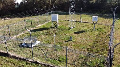
The East Armidale Weather Station looking
north-west on 10 August 2021
Updated 27 Mar 2026
Return to Weather Home.