Guyra Snowfalls
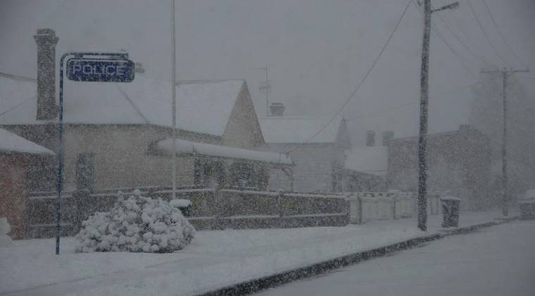
Above: Bradley
Street on 12 October 2012 during an unusually heavy spring snowstorm. Image by australiasevereweather.com
This is a brief summary of
every Guyra snowfall from 2006. Details of the unusually heavy snowfalls in
July 1984 have also been included.
The number in brackets after the date gives the approximate depth of snow
on the ground in centimetres. Zero means snow did not settle. This indication
of snow depth applies to open ground and not drifts of snow against fences,
walls or other objects.
Definitions of terms used:
Snow -
snowflakes in the form of ice crystals, most of which are branched,
sometimes star shaped.
Sleet -
rain and snowflakes falling together.
Sago snow - small
transparent ice pellets less than 5 mm in diameter, similar to soft hail. Often
incorrectly referred to as sleet.
Soft hail or snow pellets - white opaque round or conical pellets of ice, 2 to
5 mm in diameter. Often incorrectly
referred to as sleet.
Wind chill temperature - an estimate of how cold exposed skin feels in
cold, windy conditions.
3rd-4th
July 1984 (20-30)
Without a doubt the spectacular snowfalls
in the New England region on Tuesday the 3rd & Wednesday 4th July 1984 were
the heaviest and most prolonged for many years. Some older residents claimed
they were the best for at least 50 years.
An intense cold front pushed up from the south-west passing through the region
at around 9am on Tuesday 3rd July bringing in its wake very cold air and
sub-zero temperatures. Guyra's maximum temperature on Tuesday was -0.3C, and
the maximum on Wednesday was 0.5C. These were record low maximums. The minimums
were -3.0C and -6.0C respectively. The snow started at around 8am on Tuesday and continued
without stopping until the following evening with the temperature remaining
below zero for this whole time allowing snow to settle
and quickly build up to a depth of several centimetres, particularly overnight
on Tuesday. The snow was deep on the ground on Wednesday morning (exact depth
unknown). The New England Highway was blocked south at the Devil's Pinch and
several other locations north between Guyra and Glen Innes. The railway line
was also blocked north of Dumaresq. The outbreak was so intense that snowfalls
extended over the border into south-east Queensland with snow falling in
Toowoomba for the first time in 25 years.
Because of the depth of snow, council graders were used to clear some of
Guyra’s streets to allow movement of snowbound traffic around the town.
4th
August 2006 (1)
Snow fell with large flakes around 3cm in size from
5.15 to 5.45pm and settled briefly on the ground to give a light cover, but
melted about two hours later.
7th
September 2006 (0)
6am to 10.30am -
Intermittent light snow fell, but did not settle on the ground.
16th November 2006 (1)
A severe cold front
passed through northern New South Wales producing light and moderate snowfalls
from early in the morning until 1pm, but only settled to give a patchy cover on
the ground. Two further moderate snow showers at 1pm and 2pm settled briefly
before melting soon after.
The maximum temperature for the day was just 8.2C which
was the lowest for November for 20 years. The minimum of -1.6C was a new record
low for November (previous lowest -1.1C on 12th & 13th November 1965), but
this was broken the following morning, the 17th, with a minimum of -2.6C and a moderate frost caused by the very cold air following the
front.
8th-9th June 2007 (5)
On the 8th showers of sago snow (soft hail) fell in the late afternoon and
evening. Heavier snow fell between midnight and 4am on the 9th. Snow lay on the
ground up to 5 cms deep in places until mid morning on
the 9th when it melted off. Maximum temperature on the 8th was 5.0C, and
minimum on the 9th was -1.0C.
Photographs of this event by
Australian Severe Weather: 8th
June & 9th
June.
19th-20th
June 2007 (2)
Snow fell overnight
and in the early hours of the morning (11.30pm to 1am approx) settling on the
ground to a depth of 2 cms with a light cover remaining on the ground at 9am.
It was Guyra’s coldest day for 9 years with a minimum temperature of -5.0C and
a maximum of only 2.6C.
27th-28th June 2007 (3)
Snow started falling
in the evening of the 27th with moderate falls through the early hours of the
28th. In the morning snow was 3 cms deep on the ground aided by a brief heavy
fall at 9am with lighter intermittent falls throughout the day until sunset.
Snow remained on the ground until around mid afternoon. It was extremely cold
with the wind chill temperature at 3pm being around -9C. The maximum
temperature to 3pm was just 1.8C, although the official top for the day was
3.8C as measured at 9am on the 29th.
Photographs
of this event on 28th June by Australian Severe Weather here.
8th-10th
July 2007 (8)
8th - Snow showers fell
throughout the day from 8.30am with the heaviest falls around 3pm, and 6 to 7pm
after which snow lay on the ground about 8 cms deep. Maximum temperature was
4.1C.
9th - Snow fell briefly from 8.30 to 9am settling about 1 cm on the ground.
10th - Light intermittent snow fell throughout the day but did not settle.
Photographs
of this event on 8th July by Australian Severe Weather here.
17th-18th May 2008 (7)
A strong cold front brought early season snowfalls with moderate snow falling
from around 9.30pm to 11pm in the evening of the 17th. There were lighter falls
at around 9am on the 18th. Snow was 7 cms deep on the ground at 9am, but had mostly melted by 12noon. Maximum temperature on
the 18th was 5.9C, the coldest May maximum for eight years. Strong westerly
winds during the day kept wind chill temperatures around -5C to -10C.
Photographs of this event by
Australian Severe Weather: 17th
May & 18th
May.
9th July 2008 (8)
A strong cold front and upper level cold pool passed
through the region bringing light snow showers in the morning, and heavier snow
showers in the afternoon from around 2.30 to 6pm. By late afternoon snow was 8
cms deep on the ground where it remained until late the following morning when
it melted. Maximum temperature on the 9th was just 1.8C which
was the lowest for any month since August 1996. Snowfalls on 9th July 2008 were
widespread on the Northern Tablelands with falls from Hanging Rock in the south
to Tenterfield in the north.
27th-28th July 2008 (3)
A pool of cold air from the south swept over the Northern Tablelands in the
afternoon of the 27th July. Showers of snow and sago
(soft hail) commenced at 3pm and lasted until around 9pm settling on the ground
to a depth of about 3 cms. There were more snow showers, mostly sago, around
the middle of the following day, the 28th. The maximum temperature on the 28th
was 4.2C. In this event snowfalls extended north over the border into southern
Queensland where the Stanthorpe area had light settling falls.
Photographs of this event on 28th
July by Australian Severe Weather here.
5th-6th August 2008 (1)
A cold change brought a brief blast of cold air in the late evening of 5th
August with light snow falling overnight and early in the morning of the 6th.
At 9am on the 6th there was a light patchy cover of snow on the ground which
melted soon after.
A further cold change in the evening of 7th August brought very light snow to
the Ben Lomond area, but no snow was observed in Guyra.
23rd August 2008 (2)
A cold front passed through the region in the evening of the 22nd August with strong
winds and low temperatures. It snowed in the early hours of the morning
starting at or just after midnight, and settled on the
ground to a depth of about 2 cms. The snow was still on the ground at 7am but
melted quickly under early morning sunshine. This system also delivered
settling snow to Walcha and further south at Hanging Rock.
22nd October 2008 (0)
A severe cold front passed through in the afternoon plunging the temperature
from 12C at 3pm to around 3C at 4pm. Snow fell from 4.00 to 4.25pm in large wet
flakes which did not settle on the ground. There were further
light snowfalls in the evening.
10th
June 2009 (0)
A severe cold front
passing through the north of the state produced a light snow shower at 8.45am
which lasted about 15 minutes. Later at around 10am there were light snowflakes
mixed with rain (sleet) for a brief period. The maximum temperature for the day
was 5.7C with a 3pm wind chill temperature of -10C as a
result of strong 46 km per hour westerly winds.
15th
July 2009 (7)
As very cold air moved over the Northern Tablelands snow showers developed in
the afternoon and evening. The heaviest fall was from 7.00 to 7.30pm with large
flakes settling on the ground to a depth of around 5 to 7 cms. Snow remained on
the ground until soon after dawn the following morning when it melted rapidly.
Cold showery weather on the 16th kept the temperature down to a maximum of 4.7C
with a 3pm wind chill temperature of -9C. There was no snow on the 16th apart
from a little sleet.
Photographs of this event by
Australian Severe Weather: 15th
July & 16th
July.
3rd
July 2010 (1)
From
approximately 7am to 9am there were light snow showers which settled briefly to
give a very patchy cover, but melted soon after 9am. Minimum for the day was
-0.6, maximum 5.9C.
2nd
August 2010 (1)
A fast moving cold change with strong wind gusts passed through the Northern
Tablelands in the early hours of the morning bringing snow showers to the Guyra
region between 3am and 6am. Snow settled on the ground to a depth of about one
centimetre, but melted soon after 9am. Further light snow fell in the evening
between 8 and 10pm with snow settling to a depth of around one centimetre. It
melted a few hours later. It was a bitterly cold day on the 2nd with an
overnight minimum of -1.6C and maximum 5.9C. The 3pm wind chill temperature in a
40 km per hour wind was -9C.
12th
August 2010 (0)
Strong westerly winds following a cold front brought showers, sleet and snow
during the day. There were several light snow showers
up until around 3pm interspersed with rain and sleet showers. The snow did not
settle. The maximum temperature was just 3.5C, and the gusty winds made it very
unpleasant to be outside. The wind chill temperature
throughout the day varied between -10C and -15C. The average wind speed at 3pm
was 57 km per hour.
Photographs of this event by Australian Severe Weather here.
26th
August 2010 (0)
A cold front brought very strong winds and rain showers with a few brief snow
showers in the early morning. The snow did not settle. The maximum temperature
was 6.3C, however with wind speeds exceeding 60 km per hour, the wind chill
temperature was around -14C to -16C for most of the day.
16th
October 2010 (0)
A severe cold front swept through the region with rain, galeforce winds and
snow. Snow fell in showers from 6.30am to 10am, but
did not settle on the ground. Strong winds and low temperatures made it very
uncomfortable outdoors. The temperature at 3pm of 6.1C combined with a 78 km
per hour wind produced a wind chill temperature of -12C. The maximum of 6.8C
was the lowest for the month of October on record (36 years of records). The
previous lowest was 7.2C on Oct 6th, 1983. Dry air following the front dropped
the temperature to -1.7C the following morning with a frost.
Total rain from this event was 38.0 mm.
19th
July 2011 (1)
An upper level pool of cold air moved over the Northern
Tablelands during the morning generating showers of soft hail which partly
whitened the ground, and a moderate shower of snow from 2.55 to 3.30pm along
with very strong winds. The snow settled briefly on the ground. The maximum
temperature was 4.8C, and the wind chill temperature at 3pm was around -11C in
the strong south-westerly wind.
9th
August 2011 (1)
An upper level pool of cold air over northern New South Wales
brought cold icy conditions to the Guyra region. There were one or two very
light snowfalls during the early hours of the morning, but
only settled on the ground to a minor extent. There were several showers of
soft hail during the day up until around lunchtime. Maximum temperature was
6.7C, 3pm wind chill temperature was -5C.
18th
August 2011 (0)
A severe
cold front brought windy and icy conditions during the day. From around 10am to
1.30pm there were several showers of soft hail, and from 1.30 to 2.30pm there
were snow showers interspersed with rain. The hail partially whitened the
ground, but the snow did not settle. The maximum temperature was 6.6C, and the
wind chill temperature at 3pm was around -8C in the
strong westerly wind.
9th-10th
September 2011 (2)
A few light showers of soft hail/sago snow occurred during the day of the 9th,
along with rain. In the early hours of the 10th there were several snow showers
which left a light cover on the ground 1 to 2 cm deep. These snow showers
occurred from approximately 1am to 6am, with some very fine snowflakes falling
until around 9am. This was the heaviest snowfall in
2011. Maximum temperate on the 9th: 8.1C. Minimum on the 10th: -1.1C. Maximum
on the 10th: 6.2C. The wind chill temperature at 3pm on the 10th was -5C. Total
rain and melted hail/snow from this event: 22.2 mm. A surface trough and upper
level cold pool were responsible for this event.
Photographs of this event by Australian Severe Weather here.
1st
October 2011 (0)
As a trough passed through the tablelands, it
brought thunderstorms, showers and low temperatures. There were several showers
of small hail, and a light shower of snow at around 6pm which did not settle.
The heaviest of the hail showers just after 3pm whitened the ground.
5th
June 2012 (0)
An
upper level pool of cold air passed over the Northern
Tablelands bringing light snowfalls to the higher areas including Guyra, Black
Mountain and Ben Lomond. These falls were intermittent and light,
and did not settle on the ground apart from a brief shower of sago snow
at around 4pm. Maximum temperature was just 3.1C with wind chill temperatures
well below zero throughout the day. This was Guyra’s coldest day since 9th July
2008 (1.8C).
28th
July 2012 (1)
Light showers of snow fell in Guyra early in the morning. It started
around 6am and snowed intermittently until just before 9am. There was a very
light cover on the ground at 6.30am. A surface trough
and upper level cold air brought the
unexpected snow. The maximum temperature for the day was 6.3C with the
wind chill keeping the temperature around 1C or less.
1st
August 2012 (1)
An upper level
pool of cold air over the eastern half of New South Wales contributed to some
unexpected snowfalls around Black Mountain and Guyra in the evening. A series
of four showers moved across the Northern Tablelands from the south-west
between Armidale and Guyra between around 9.30 and 10.30pm. With surface
temperatures between 1 and 3 degrees the showers arrived as snow settling on the ground to some extent around Black Mountain
and to a lesser extent in Guyra. The sky cleared at around 11pm allowing the
temperature to drop well below freezing which resulted in a combination of
frost and snow on the ground in Guyra the following morning, 2nd August.
Because of ice and snow on the road the New England Highway at the Devil’s Pinch
south of Guyra was closed overnight from around 11pm to 9am. This was an
unusual event with snow followed by clear skies and severe frost. Also the showers were confined to a very localized area.
Guyra’s minimum temperature on 2nd August was -4.6C.
12th
October 2012 (10)
A cold snap brought moderate to heavy
snowfalls to Guyra and surrounding areas with snow falling from shortly after
midnight intermittently through to 9.30am The heaviest
falls were between around 4am and 9am. At 9am the snow was around 10 cms deep
on the ground before it gradually started to melt at around 11am.
Temperatures were very low during the day with a maximum of just 4.0 C. Strong
westerly winds made it feel much colder with a 3pm wind chill temperature of
-8C. This was Guyra’s coldest October day on record (38 years of records). The
previous lowest was 7.2C on 6th October 1983. It was claimed by many residents
to be the heaviest Guyra snowfall for at least 20 years. Temperatures were low
enough to allow some of the larger ‘snowpersons’ in a number
of front yards to survive overnight into the following day.
The snowy conditions were caused by cold surface
temperatures following the passage of a trough, enhanced by an upper level cold pool, and moisture being added to the
system by a low pressure system off the NSW coast. It
also snowed in Tenterfield along with a few light falls in southern Queensland
around Stanthorpe.
Photographs of this event by Australian Severe Weather here.
25th
June 2013 (1)
Low temperatures, showers and snow occurred along the Northern Tablelands
during the morning. An upper level cold pool combined
with showers being pushed northwards from a low pressure
system near Sydney produced the very cold conditions. Light snow fell and
settled on the ground in the Guyra/Black Mountain/Ben Lomond area, and further
east around Ebor. In Guyra the snow started at around 3am, lasting for about
two hours and settling on the ground about a centimetre deep. Most of it had
melted by 9am. There were a few very light showers of snow mixed with rain
(sleet) during the morning. The maximum temperature was 4.1C with the 3pm temp
at 2.6C.
Photographs of this event by Australian Severe Weather here.
3rd-4th
May 2014 (0)
Temperatures plunged to mid-winter levels on the 3rd as a severe cold
front passed through northern New South Wales bringing showers, strong winds,
low temperatures and some light snowfalls to higher parts of the Northern
Tablelands. The Guyra/Black Mountain/Ben Lomond areas all received a few light
snow and sleet showers.
In Guyra there were a few light snow showers in the evening of the 3rd and
early in the morning of the 4th, but barely settled on
the ground. Maximum temperature on the 3rd was just 4.6C, but the strong winds
caused the wind chill temperature to be around -5C to -10C for most of the day.
Minimum on the 4th was -1.1C, maximum on the 4th was 4.1C - coldest May day
since 30th May 2000 (3.5C).
Photographs of this event by Australian Severe Weather: 3rd
May & 4th
May.
30th
June 2014 (1)
An upper
level cold pool combined with moist surface westerly winds generated snow
showers over the higher parts of the Northern Tablelands. In Guyra light snow
fell in the early hours with a patchy cover on the ground until around 9am when
it melted. There were further brief snow showers
between 10am and noon, but did not settle. Conditions
were very cold during the day with a maximum of just 3.8C and a 3pm wind chill
temperature of -4C in the south-westerly winds. Light snow also fell around
Black Mountain and Ben Lomond.
18th
July 2014 (3)
As
an intense cold front swept through New South Wales in the early hours, snow fell
in a wide area of the Northern Tablelands including Niangala, Walcha, Uralla,
Armidale, Ebor and Ben Lomond. In Guyra there were early morning snow showers
with snow settling about 3 cms deep on the ground at 9am. It had melted by 12
noon. Winds during the day were very cold south-westerlies.
The maximum temperature was just 2.5C, but the wind chill temperature remained
between -6C and -10C throughout the day in the strong winds. This was Guyra’s
coldest day since 9th July 2008 (1.8C max).
3rd
September 2014 (1)
A cold front passed through the
Northern Tablelands during the afternoon of the 2nd with strong gusty winds and
several showers of soft hail (sometimes referred to as sleet or sago snow)
during the afternoon and evening. In the early hours of the 3rd there were
light snow showers with a patchy cover on the ground at sunrise. It melted soon
after 9am. Light snow also fell around Ben Lomond, Black Mountain and Ebor with
heavier falls further south around Hanging Rock.
5th
June 2015 (0)
A
cold snap brought low temperatures and light snow to the Guyra Area. During a
light shower of rain at around 12.30pm large snowfakes fell for about 20
minutes but did not settle on the ground. Snow and rain mixed is normally
referred to as “sleet.” A trough moving through eastern New South Wales
combined with an upper level pool of cold air was
responsible for the low temperatures and snow. The maximum temperature for the
day was 6.2C.
12th-13th
July 2015 (8)
A severe cold front combined with a large upper level
cold pool passed through the region early in the morning of the 12th with
snowfalls to the Guyra area. Snow settled on the ground in the morning, and
there were further snow showers during the day. The
maximum temperature of just 2.9C combined with strong westerly winds made it
bitterly cold to be outside. However many snow
sightseers travelled to the area to witness and play in the snow.
On the 13th further snow fell in the early hours and through the morning. Snow
settled on the ground to a depth of around 8 centimetres. It was another icy
cold day with a minimum of -3.5C up a maximum of 2.8C.
Photographs of this event by Australian Severe Weather here.
16th-17th
July 2015 (3)
In a second major snow event for the month, an upper level trough
and cold pool moved through eastern New South Wales on the 16th bringing very
low temperatures and widespread snowfalls to the Central Tablelands, Northern
Tablelands and over the border into southern Queensland including Stanthorpe
and Cunningham’s Gap. The snow started late in the evening of the 16th and
continued through till mid-morning on the 17th.
In Guyra snow was around 3 centimetres deep on the ground in the early morning
on Friday, but had mostly melted by the afternoon. The
maximum temperature for the day was 3.5C, with wind chill temperatures below
-5C in the icy westerly winds.
6th August 2015 (1)
Light snow showers fell over the higher parts
of the Northern Tablelands in the early hours of the morning, including Guyra,
Black Mountain and Ebor. In Guyra there was a patchy cover of snow on the
ground at dawn which had melted by about 9am. The maximum temperature for the
day was 6.5C. A cold front which passed through the region overnight brought
the cold snowy conditions.
24th
June 2016 (1)
A
severe cold front passed through the Northern Tablelands in the afternoon with
strong winds and showers. Very cold air following the front brought light snow
showers to higher parts of the region in the evening. In Guyra there was a
light fall of snow around 9pm which remained on the ground well into the
following morning. Temperatures on the 25th: minimum -3.0C, maximum 5.0C.
27th
June 2016 (5)
Very cold air associated with a low pressure trough
and upper level cold air brought snowfalls and low
temperatures to the Guyra area. After a few light snow showers during the day,
the best falls came in the evening from around 6pm with snow settling on the
ground to a depth of around 5 cms.The snow remained on
the ground overnight and into the following morning. It was Guyra’s coldest day
for 18 years with a maximum temperature of just 2.2C, lowest since 31st July
1998 (2.0C).
Photographs of this event by
Australian Severe Weather: 27th
June & 28th
June.
5th-6th July 2016 (2)
Cold air following the passage of a cold front
on the 5th brought light snow showers to the Guyra area in the late evening and
following morning with a very light cover on the ground on the 6th. There were
further light snow showers through the day which was
also a day of strong winds and low wind chill temperatures. Maximum wind gust
was 63 km per hour at 10.43am, measured in South Guyra. The maximum temperature
on the 6th was just 3.1C, but the wind chill temperature for most of the day
was between -1C and -5C. Light snowfalls also occurred around Ben Lomond and
Black Mountain.
18th
June 2018 (4)
Light to
moderate snow fell from around 3am to 10am with snow settled on the ground to a
depth of about 4 cms at 9am, but had melted by around
10am. The minimum temperature was -1.3C and the maximum was only 3.6C at
12.45pm, although in the strong winds the wind chill temperature was around -3
to -5 degrees for much of the day. The cold snap and snow was
caused by upper level cold air, and showers being
forced onto the Northern Tablelands from a deep southerly airflow onto the New
South Wales coast.
7th
July 2018 (0)
As
a fast moving cold front passed through north-east New
South Wales snow showers occurred on the higher parts of the Northern
Tablelands. Light snow fell in Guyra at 8pm for about five minutes,
but did not settle on the ground.
4th
June 2019 (6)
Cold
southerly winds combined with an upper level pool of
cold air resulted in snowfalls over the Northern
Tablelands in the early hours of the morning. Snow started falling in Guyra
after midnight and there was a 6 cm cover on the ground at 8am. Light snow
showers continued through the morning until around 11am. Snow on the ground
melted slowly from 9am and was gone by around midday. The minimum temperature
for the day was -1.9C with a maximum of just 5.0C.
10th-11th
August 2019 (3), (6)
Very
cold surface air following the passage of cold fronts on Friday 9th and
Saturday 10th combining with upper level cold air produced snow over the
Central and Northern Tablelands on the weekend.
In Guyra light snow started in the late evening of the 10th and became heavier
in the early hours of the 11th with snow settling on the ground to a depth of 3
to 4 cms. It remained on the ground, melting by 11am.
The second fall for the weekend started at 8.30pm on Sunday 11th, lasting for
about an hour with snow settling to a depth of around 6 cms. It was still on
the ground the following morning Monday 12th, but had
mostly melted by 10am.
The
maximum temperature on the 11th was just 5.4C, but strong westerly winds
gusting to over 60 km per hour during the day caused the wind chill temperature
to remain well below zero. The total weekend rainfall was 3.4 mm of melted
snow.
9th
September 2019 (0)
Light
snow showers or flurries fell from 3.30 to 4.30pm approximately. Snow did not
settle on the ground. The snow showers developed in a cold southerly airstream
in the wake of a cold front which passed through the region on the 7th.
2nd
June 2020 (0)
Snow fell for about an hour from 8.30 to
9.30am but did not settle on the ground. Very cold conditions resulted in light
snowfalls along parts of the Northern Tablelands including Armidale. Cold
south-westerly winds following the passage of a cold front the previous
evening, and an upper level cold pool caused the
extreme wintry weather. The maximum temperature for the day was 5.3C.
22nd June 2020 (0)
Very cold winds combined with an upper level cold pool following a cold front which passed
through eastern New South Wales on the 21st, resulted in very light snow on the
higher parts of the Northern Tablelands on the evening of the 22nd. Light
non-settling snow fell briefly in the evening at around 9pm in Guyra. Low day
temperatures followed on Tuesday 23rd with Guyra recording a maximum of just
3.8C.
13th July 2020 (0)
Very
light snow fell briefly between 5 and 6pm but did not settle on the ground.
Heavier falls occurred further north around Llangothlin and Ben Lomond. The icy
conditions were caused by cold surface westerly winds generated by a low pressure system over southern New South Wales combining
with upper level cold air. The maximum temperature on
the following day the 14th was 5.0C.
9th August 2020 (0)
Light
snow fell briefly at around 7am and 12 noon, and again in the evening. It did
not settle on the ground but the Ben Lomond area
received heavier falls which settled in the evening of the 9th and early
morning of the 10th. An upper level cold pool of air
combined with cold surface southerly winds associated with a low
pressure trough produced the snowy conditions. The maximum temperature
on the 9th was 4.4C.
22nd August 2020 (0)
A severe cold front which passed through
north-east New South Wales in the early morning brought showers of small hail
and snow to higher parts of the Northern Tablelands. In Guyra there were a number of showers of soft hail (often referred to as sago
snow or sleet) throughout the day, however there was only one brief very light
shower of snow at around 12.20pm when the temperature dropped to 0.5C. The
maximum for the day was 6.2C at 11am, however strong westerly winds kept the
wind chill temperature to below zero degrees for most
of the day. This was not recorded as a “snow” day.
9th-11th June
2021 (8)
Low temperatures, strong winds and showers of
rain and snow occurred on the Northern Tablelands after a cold front passed
through the region late on the 8th. A low pressure
system associated with the front developed over southern New South Wales on the
9th which generated cold west to north-westerly winds over the north of the
state. This surface system combined with upper level cold air caused snow to
fall over the higher areas of the tablelands including Guyra, Black Mountain
and Glen Innes on the 9th and 10th.
In Guyra: 9th - light flurries during the day, heavier in the evening with snow
settling on the ground to a depth of about 4cm. Max temp: 4.4C.
10th - light snow showers during the day but not settling. Heavier snow in the
evening between 9pm and around midnight with snow settling to a depth of 8 to 9
cms. Max temp: 2.5C
Fri 11th - rain and higher temperatures in the early hours of the morning
caused the snow to melt.
20th-21st July 2021 (4)
A cold front with associated upper
level cold air moved through the Northern Tablelands bringing snow to
areas around Walcha and to the Guyra-Black Mountain-Ben Lomond area. In Guyra
snow showers commenced at around 10pm on the 20th with snow settling on the
ground. Further snow showers occurred through the night and morning of the
21st. At 6am snow was about 4 cms deep on the ground but gradually melted later
in the morning. Very light snow continued until around 12 noon.
24th-25th August 2021 (1)
A severe cold front passed through
north-eastern New South Wales in the early hours bringing moderate falls of
rain to the Northern Tablelands and snow in elevated areas. In Guyra rain in
the early morning turned to snow at around 7am, but
only settled briefly on the ground. A moderate snow shower at around 11am,
lasting about 30 minutes, also settled briefly before melting. During the
afternoon there were a number of brief light snow
showers, and also small hail (often referred to as
sago snow or sleet). The maximum temperature was 4.4C at 9.50am, but strong
winds throughout the day gusting to 60 km per hour kept the wind chill
temperature well below zero degrees. Rainfall: 33.8 mm for the 4 hours to 9am
with a further 6.0 mm falling during the day.
Further light showers of snow fell in the early morning of the 25th.
14th
September (0)
A
cold front brought chilly showery conditions to the Northern Tablelands. In
Guyra there were several very light snow showers
during the day with small flakes, but not settling on
the ground.
21st September 2021 (1)
Very
cold air following a severe cold front which moved through north-east New South
Wales late on the 20th produced showers of snow and hail on the higher areas of
the Northern Tablelands. In Guyra there were a several
light snow showers during the morning after 9am with a heavier snow shower at
around 2pm which briefly settled on the ground. At 4pm there was a heavy shower
of small hail (sometimes referred to as sago snow) which lasted for about ten
minutes with 80 per cent of the ground whitened. Maximum temp: 6.5C, rain to
9am on 22nd: 0.4 mm, maximum wind gust: 55 km/hr at 12.45pm.
13th July 2022 (0)
Light
snow fell from around 11.30am for about 20 minutes but did not settle on the
ground. Light showers of sago snow then occurred intermittently until around
5pm. Maximum temperature was 5.1C, but dropped to 1.0C
at 11.45am during the morning snowfall. Cold south-westerly winds combined with
upper level cold air following the passage of a cold
front and trough caused the snowy conditions.
23rd August 2022 (4)
A fast moving severe cold front passed through
the Northern Tablelands bringing strong winds, showers, low temperatures, and
snow to the higher areas in the evening. In Guyra a ten
minute shower of hail at around 6pm was followed by moderate to heavy
snow showers from around 7pm to 8pm easing to intermittent light snow showers
for the remainder of the evening. Snow settled on the ground to a depth of 4 to
6 cms, and was still on the ground the following morning, melting later in the
day. Temperatures hovered around zero to -1C from 7pm during the snowfalls.
18th May 2024 (0)
A
surface low pressure trough combined with an upper level
disturbance generated clusters of thunderstorms over north-east New South Wales
during the afternoon. Storms passed over Guyra between 3 and 4pm with rain and
hail which whitened the ground. After the storms the temperature dropped to
1.5C with brief flurries of snow which did not settle.
15th-17th July 2024 (1)
A deep low
pressure system near Tasmania directed cold air from the Southern Ocean
into New South Wales. Upper level cold air combined
with this system to produce low temperatures and snowfalls
over the Central Tablelands, Barrington Tops, Northern Tablelands, and some
light snow also falling in southern Queensland.
In Guyra light snow fell in the early morning of the 15th with some settling on
the ground. On the 16th intermittent snow, moderate to
heavy at times, and sago snow (ice pellets) fell throughout the day with little
or no settling. On the 17th intermittent small
snowflakes fell throughout the day with no settling.
Minimum/maximum temperatures:
15th: 1.0C/6.1C, 16th: -0.8C/4.6C, 17th: 0.9C/3.8C.
Strong winds on the 16th caused wind chill temperatures to drop as low as -6C
during the morning.
9th June 2025 (0)
Very
cold, windy and showery conditions affected the Northern Tablelands with light
snowfalls in the higher areas including Black Mountain, Guyra and Ben Lomond.
In Guyra the heaviest snow occurred in the morning around 10am with lighter
intermittent falls during the rest of the day. Due to the temperature not being
quite low enough, and the wet ground, the snow mostly did not settle. The snowy
conditions were the result of very cold south-westerly winds following a front
and low pressure trough combined with upper level cold air. After a minimum temperature of 0.7C,
the maximum for the day was only 4.9C, although the strong westerly winds made
it feel much colder. This temperature was the lowest June maximum for four
years.
2nd July 2025 (2)
Light
snowfalls occurred in the early hours of the morning, settling on the ground to
a depth of around 2 cms. The snow remained on the ground until around 11am when
it melted. Strong winds, cloud and drizzle
persisted throughout the day with the temperature reaching a maximum of 6.1C,
although the winds made it feel much colder. The snowfalls were produced by low
surface temperatures and showers being driven inland by an intense low pressure system off the New South Wales Hunter coast.
2nd August 2025 (30+)
Snow
fell over a wide area of the Northern Tablelands during the day. In Guyra the
snow started in the early hours and continued throughout the day, finally
stopping at around 5.30pm. The snow was at its heaviest from around 10am to 12
noon. By late afternoon snow covered the ground to a depth of about 30 cms.
The snow extended south to Walcha and the Moonbi Range, east along the Snowy
Range to Ebor, and north to Glen Innes and across the border to the Granite
Belt where there were light falls in the Stanthorpe area, and also west to Bundarra and the
Narrabri area. The New England Highway was closed north and south of Guyra due
to snow and fallen trees, and also the road east to
Ebor. Many areas also experienced loss of electricity for extended periods due
to fallen trees across power lines.
On 3rd August snow remained on the ground in Guyra before melting later in the
day.
The snowfalls were the result of upper level cold air
over northern New South Wales combined with moisture from the east along a
surface low pressure trough associated with an intense low
pressure system off the New South Wales North Coast.
Temperatures stayed around or below freezing for most of the day, with the
maximum from 5am to midnight being 0.8C at 6.45am.
This was estimated to be Guyra’s heaviest snowfalls
since the big snow event on 3rd-4th July 1984.
Can you supply information on any Guyra snowfalls not listed here?
If so please send the details via the email link below and they will be added
to this archive.
Email link.
Back to Guyra Weather homepage.